News & Public Involvement

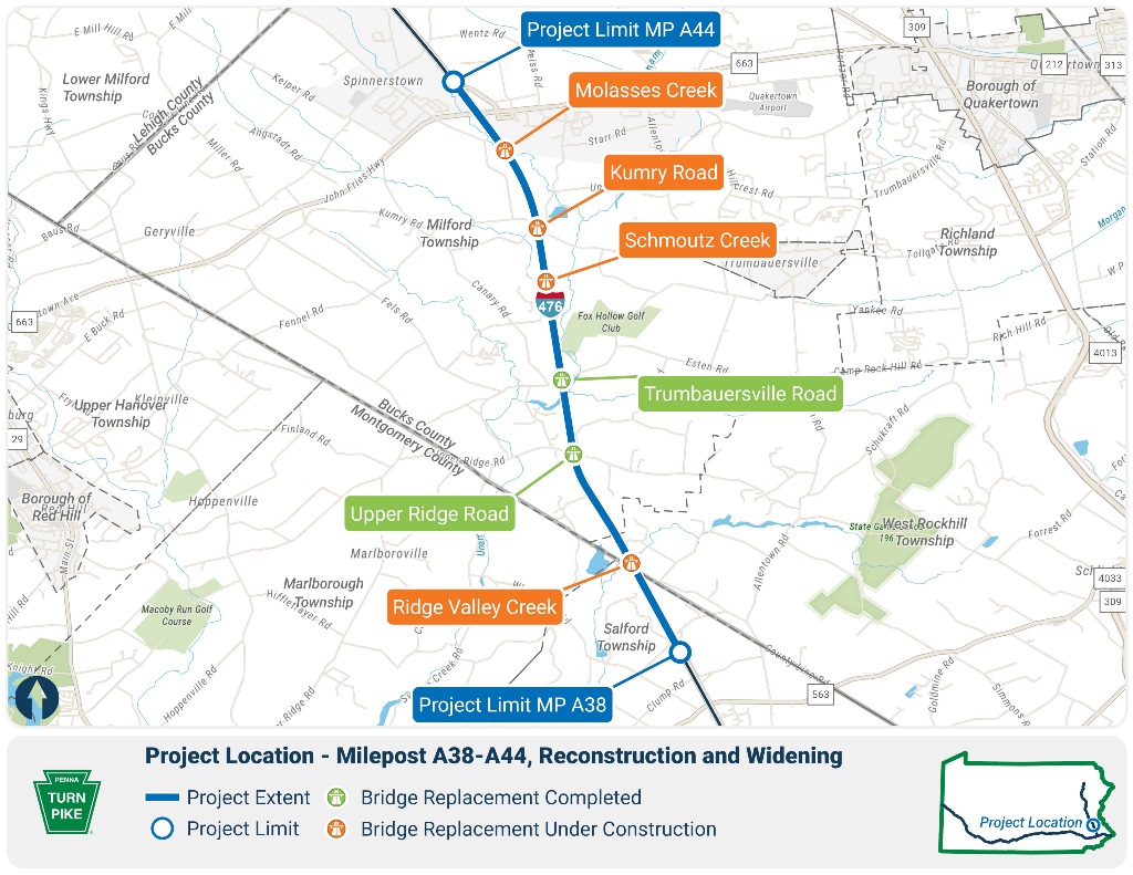
Milepost A38-A44 Total Reconstruction News & Public Involvement

Sign up...

to receive project news, outreach messages, and travel restrictions via email.

PTC NE Extension Email Signup Form

* indicates required

December 3, 2014 Public Open House Plans Display

The Turnpike hosted an Open House Plans Display on Wednesday, December 3, 2014 at the Pfaff Elementary School in Quakertown, PA. Click on the links below to review the materials presented at the display.

Preliminary Design Open House Plans Display Handout

Preliminary Design General Project Information Displays

Preliminary Design Noise Analysis Displays

Preliminary Design Plans*

These plans reflect the preliminary Design as of December 3, 2014 and are subject to change as the project progresses.

Preliminary Engineering Noise Analysis Report

PennDOT Noise Publication

Project Photo Album

Construction Progress Photos

Pennsylvania Turnpike Commission Releases 2022 Sustainability Report

The report highlights initiatives the Commission is doing toward a sustainable future.

April 19, 2023 – The Pennsylvania Turnpike Commission (PTC) announces the release of its 2022 Sustainability Report. The annual report features the Commission’s 30-year timeline outlining initiatives for the future as well as the progress in making the PA Turnpike ‘America’s First Sustainable Superhighway.’
 
As part of its continued alignment with the  United Nations’ 17 Sustainable Development Goals, the 2022 Sustainability Report also details PTC's efforts to safeguard the environment and reduce its carbon footprint along the 550-mile roadway.
 
“Protecting the environment through sustainability has been a guiding principle,” says PA Turnpike CEO Mark Compton. “In fact, ‘Responsibility Matters’ is one of five core values in our strategic plan, underscoring an ongoing commitment to diversity, integrity, and sustainability in all practices. Heeding the UN’s Sustainable Development Goals helps us create programs and initiatives to deliver on our promise of a regenerative future.”
 
In this year’s report, PTC states its plan to become America’s First Sustainable Superhighway by 2040. These leading initiatives include converting fully to Open Road Tolling (ORT) by 2026 and integrating solar, fiber, inductive charging, connected-vehicle technology, buried electronic transmission lines, and more by 2040—all to increase mobility and traffic flow while reducing the Commission’s carbon footprint.
 
Selected Highlights from PTC’s 2022 Sustainability Report:
  • Fiber Optic Network: When complete, the 500-mile fiber-optic network will reduce carbon footprint and extend broadband to help close the digital divide in underserved areas along the Turnpike.
  • Pollinator Garden: A pollinator habitat has been cultivated at the Turnpike central office to replace grassy areas with native plants that attract and provide a habitat for insects like bees and butterflies. The outcome is reduced mowing and insecticide use along with lower maintenance costs.
  • Roadside Vegetation: An Integrated Roadside Vegetation Management pilot program offers an environmentally safe maintenance approach to restore native and natural habitats, filter pollution, reduce erosion, and improve ecosystem diversity along the roadside.
  • Wireless EV Charging: Currently in development is a project to charge Electric Vehicles (EVs) as they drive. A method of wireless power transfer called “inductive charging” employs coils embedded in the pavement to create a magnetic field that is ‘picked up’ by a receiver on EVs.
The report includes the Pennsylvania Turnpike Commission’s ongoing commitment to its employees and the communities they call home. Throughout 2022, PTC and its employees raised more than $28,000 for charities through their State Employee Combined Appeal Campaign, volunteered at several Food Banks across the state, collected supplies and donations to support Ukraine troops, and hosted local female high school students for a STEAM Day.
 
Click on 2022-ptc-sustainability-report.pdf (paturnpike.com) to learn more about the Pennsylvania Turnpike Commission’s sustainability efforts and view the 2022 report.
 
Editor’s Note: Video soundbites of the report’s highlights can be found by clicking the links below.
 
Keith Jack, Director of Facilities Operations for the PA Turnpike Commission discusses:
 
Sustainability Report
EV Charging at the Turnpike
Fiber Optic Project
 
James Kaiser, Stormwater Management Specialist for the PA Turnpike Commission discusses:
 
Pollinator Habitat Project
Vegetation Project
 
Media Contact:
Kathleen Walter, 267-326-3856

Archaeology

The reconstruction and widening of the Pennsylvania Turnpike's Northeast Extension (I-476) between mileposts A38-A44 involves the addition of travel lanes and the removal and replacement of five bridges. According to Section 106 of the National Historic Preservation Act (NHPA1966), Federal agencies must consider the effects of federally funded, licensed, or permitted projects on historic properties and afford the Advisory Council on Historic Preservation (ACHP) an opportunity to comment on such projects.

A historic property is any property that is included in, or eligible for inclusion in, the National Register of Historic Places (NRHP). NRHP listed or eligible properties fall into five broad categories: Buildings, Structures, Sites, Objects, and Districts. As nearly every major turnpike project requires permits from federal agencies like the U.S. Army Corps of Engineers, an archaeological survey is routinely a part of the planning process needed in order to comply with the NHPA and 36CFR Part 800, the Advisory Council on Historic Preservation regulations that implement the NHPA, Section 106 process. Determining the effect of any project on archaeological resources is, therefore, an important component of the planning process for any transportation project and the PTC MP A38-A44 project is no exception.

Archaeological investigations typically involve three phases. Phase I identification survey is a reconnaissance survey which is often subdivided into Phase IA and Phase IB. Phase IA survey is the most basic type of survey focused on establishing the environmental, Pre-contact, and Historical contexts for the project area. To do so, sources like historic maps and primary documents, scholarly research, and state archaeological site files are examined to identify the locations of former buildings and or sites of notable events in and around the project area. At the Phase IA level, the probability of encountering prehistoric sites is assessed by identifying known site locations in the area and identifying areas in the environment that share environmental similarities with those places that prehistoric peoples are known to have occupied. If at this stage it is determined that the project area will have no effect to historic properties, or areas likely to contain an archaeological site (a discreet location containing evidence of past human activity) then no further archaeological work is needed and the Section 106 process has been completed. However, if the Phase IA survey indicates that the project area has the potential to contain archaeological sites, then field testing is conducted. This initial fieldwork is commonly called a Phase IB survey.

The purpose of Phase IB survey is to identify the presence of archaeological deposits and, where possible, delineate the boundary of an archaeological site. Once an archaeological site is identified a Phase II archaeological investigation may be conducted to assess its NHRP eligibility.

During a Phase II archaeological investigation, a more robust sample of the soils within the site is examined, recovered artifacts are analyzed, and an attempt is made to determine the function and temporal association of the site. If, at the conclusion of the Phase II investigations, archaeologists determine that they have a site that meets NRHP eligibility requirements, recommendations are made to either attempt to avoid or minimize project effects to the site. If avoidance is not possible, then efforts to mitigate the effects are determined through coordination with project consulting parties, usually resulting in a Phase III Data Recovery excavation of the site.

Phase III data recovery excavations endeavor to collect and record significant information from the site by collecting and analyzing artifacts, mapping of the cultural features (i.e. foundations, pits, privies, wells, graves, hearths, pits etc.). Such excavations preserve a record of the spatial relationships of the material recovered thus maintaining a record of what occurred there.

The PTC Northeast Extension Milepost A38-A44 project has included archaeological work covering all phases of archaeological investigation described above. For more information about the work completed during each phase, click the appropriate link below.

More Project Resources

Project Overview

Learn about Milepost A38-A44 Total Reconstruction.

Learn More

Design & Construction Details

Find out about planned design & construction activities for this project.

Learn More

Team & Contact Information

Learn about the team that we will work with to complete the work on this project.

Contact the Team