FRAUD ALERT: PA Turnpike Warns of Ongoing Smishing Scam.

Chat With Us

PA Turnpike Skip to main content
Restore English
Restore English
  •  E-ZPass Login
  •  Pay a Bill
  •  Toll Calculator
  •  Open Road Tolling
  •  Help Center
  •  About Us FAQs
  • E-ZPass
    • About E-ZPass
    • Purchase an E-ZPass
    • Register my E-ZPass
    • Personal Account
    • Commercial Account
    • Toll Calculator
    • All-Electronic Tolling
  • Toll By Plate
    • About Toll By Plate
    • Pay a Bill
    • Toll Calculator
    • PA Toll Pay App
    • All-Electronic Tolling
    • Open Road Tolling
    • Unpaid Tolls/Enforcement
  • Traveling
    • About Traveling
    • Toll Calculator
    • Active Travel Advisories
    • Service Plazas
    • Safety
    • 511PA Travel Information
    • Construction Projects
  • Commercial
    • About Commercial Travel
    • Commercial E-ZPass
    • Permits & Restrictions
    • Service Plazas
    • Toll Calculator
    • Hazardous Materials
  • Business Hub
    • About Working with Us
    • Vendor Portal
    • Vendor Guide
    • Bids & RFPs
    • Vendor Resources
    • Investor Relations
    • Existing Innovation Submission

Milepost A38-A44 Total Reconstruction - Improvements

Milepost A38-A44 Total Reconstruction Improvements
  • Overview
  • News
  • Improvements
  • Construction
  • Contact

Improvements

Total reconstruction projects aim to address crucial issues to ensure safer and more efficient roadways. These projects involve the complete replacement of the pavement structure, safety and drainage upgrades, and widening to improve capacity. Additionally, they include replacing all bridges in the project corridor to meet current design standards. 

The reconstruction also addresses maintenance challenges such as milling and paving, which previously required extensive roadwork and exposed workers to traffic risks. Increasing the roadway's capacity is particularly important in high-traffic areas near Pittsburgh, Philadelphia, and the Northeast Extension approaching Allentown, where six lanes are needed to handle growing traffic demands. Completing this corridor with three lanes in each direction will eliminate bottlenecks and enhance the overall flow of traffic. 

Project Benefits

Our projects are designed to bring significant improvements and benefits to the PA Turnpike. Each project aims to enhance the efficiency, safety, and overall experience for all travelers. Below are the project benefits for this project:

SafetySafety

PavementPavement Condition

CapacityCapacity

Corridor CompletionCorridor Completion

Overhead Bridge Reconstruction

Reconstructing overhead bridges is essential to make way for the widening of the PA Turnpike below, which will improve safety and road conditions.  See below for a list of both active and upcoming bridge reconstruction projects.

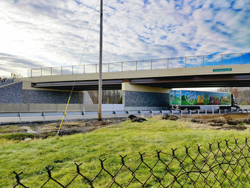
Steinsburg Road (SR 4059)

Steinsburg Road bridge over I-476 after replacement

Steinsburg Road (SR 4059) — The Steinsburg Road overhead bridge was replaced as part of early corridor work, completing construction in 2017. Following construction and approach tie-ins, the bridge was returned to service.

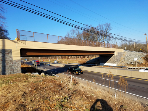
Trumbauersville Road (SR 4051)

Trumbauersville Road bridge over I-476 after replacement

Trumbauersville Road (SR 4051) — The overhead bridge was replaced, completing construction in 2017.

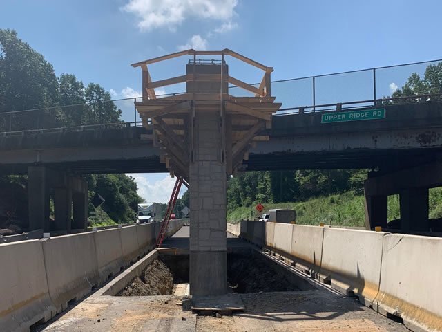
Upper Ridge Road (SR 4033)

Upper Ridge Road bridge over I-476 during construction

Upper Ridge Road (SR 4033) — The overhead bridge carrying Upper Ridge Road over I-476 was replaced in advance of the A38–A44 mainline widening and has been returned to service by the end of 2021.

Roadway Reconstruction & Widening

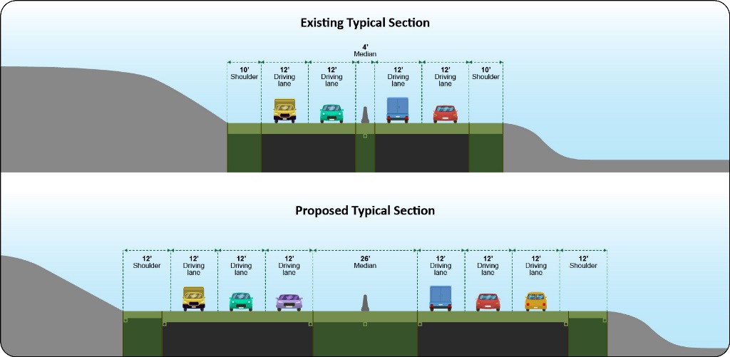
Below is a Typical Section graphic showing the configuration before and after a total reconstruction and widening project.

At project completion, the new roadway will accommodate three travel lanes in each direction, a 26-foot median, and 12-foot outside shoulders.

This image shows how the PA Turnpike will look once it is widened to three 12-foot travel lanes in each direction, a 26-foot median, and 12-foot outside shoulders.

Turnpike TV Videos

Check out Turnpike TV, the PA Turnpike’s video series highlighting our projects, daily operations, and team members. Watch below and visit our Turnpike TV page for the full series.

Construction Video

Construction

Total Reconstruction Video

Total Reconstruction

Documents

Explore our additional project documents for more information.

Noise Analysis Report: 2014

Preliminary Engineering Noise Analysis Report (2014)

PennDOT Noise Publication

Archaeology

The reconstruction and widening of the Pennsylvania Turnpike's Northeast Extension (I-476) between mileposts A38-A44 involves the addition of travel lanes and the removal and replacement of five bridges. According to Section 106 of the National Historic Preservation Act (NHPA1966), Federal agencies must consider the effects of federally funded, licensed, or permitted projects on historic properties and afford the Advisory Council on Historic Preservation (ACHP) an opportunity to comment on such projects.

A historic property is any property that is included in, or eligible for inclusion in, the National Register of Historic Places (NRHP). NRHP listed or eligible properties fall into five broad categories: Buildings, Structures, Sites, Objects, and Districts. As nearly every major turnpike project requires permits from federal agencies like the U.S. Army Corps of Engineers, an archaeological survey is routinely a part of the planning process needed in order to comply with the NHPA and 36CFR Part 800, the Advisory Council on Historic Preservation regulations that implement the NHPA, Section 106 process. Determining the effect of any project on archaeological resources is, therefore, an important component of the planning process for any transportation project and the PTC MP A38-A44 project is no exception.

Archaeological investigations typically involve three phases. Phase I identification survey is a reconnaissance survey which is often subdivided into Phase IA and Phase IB. Phase IA survey is the most basic type of survey focused on establishing the environmental, Pre-contact, and Historical contexts for the project area. To do so, sources like historic maps and primary documents, scholarly research, and state archaeological site files are examined to identify the locations of former buildings and or sites of notable events in and around the project area. At the Phase IA level, the probability of encountering prehistoric sites is assessed by identifying known site locations in the area and identifying areas in the environment that share environmental similarities with those places that prehistoric peoples are known to have occupied. If at this stage it is determined that the project area will have no effect to historic properties, or areas likely to contain an archaeological site (a discreet location containing evidence of past human activity) then no further archaeological work is needed and the Section 106 process has been completed. However, if the Phase IA survey indicates that the project area has the potential to contain archaeological sites, then field testing is conducted. This initial fieldwork is commonly called a Phase IB survey.

The purpose of Phase IB survey is to identify the presence of archaeological deposits and, where possible, delineate the boundary of an archaeological site. Once an archaeological site is identified a Phase II archaeological investigation may be conducted to assess its NHRP eligibility.

During a Phase II archaeological investigation, a more robust sample of the soils within the site is examined, recovered artifacts are analyzed, and an attempt is made to determine the function and temporal association of the site. If, at the conclusion of the Phase II investigations, archaeologists determine that they have a site that meets NRHP eligibility requirements, recommendations are made to either attempt to avoid or minimize project effects to the site. If avoidance is not possible, then efforts to mitigate the effects are determined through coordination with project consulting parties, usually resulting in a Phase III Data Recovery excavation of the site.

Phase III data recovery excavations endeavor to collect and record significant information from the site by collecting and analyzing artifacts, mapping of the cultural features (i.e. foundations, pits, privies, wells, graves, hearths, pits etc.). Such excavations preserve a record of the spatial relationships of the material recovered thus maintaining a record of what occurred there.

The PTC Northeast Extension Milepost A38-A44 project has included archaeological work covering all phases of archaeological investigation described above. For more information about the work completed during each phase, click the appropriate link below.

  • Archaeology Phase 1
  • Archaeology Phase 2
  • Archaeology Phase 3

Excess Excavation Areas

Excess Excavation Areas: Northern

Excess Excavation Areas: Southeast

Improvements FAQs

Does the PA Turnpike expect to continue widening to the north?

Yes. Design is progressing on the reconstruction and widening of the Northeast Extension between Mileposts A44 and A57 (just north of and including the Lehigh Valley Interchange). Please visit our Design & Construction page to access those project pages.

What are you doing to protect the environment?

In addition to coordinating with the local townships, the PA Turnpike continues to work with local, state and federal regulatory agencies such as the Montgomery and Bucks County Conservation Offices, the Pennsylvania Department of Conservation and Natural Resources, the Pennsylvania Department of Environmental Protection, the Pennsylvania Fish and Boat Commission, the US Army Corps of Engineers, and local special interest groups to make sure the project is completed with the least impact to the existing environment.

How did the PA Turnpike determine if noise walls would be needed?

Please watch our Noise Wall video to learn more about how the PA Turnpike determines where sound barriers will be located. 

Why is this project being built?

This project is part of the Pennsylvania Turnpike Commission’s (PTC) $2 billion system wide total reconstruction initiative which entails rebuilding sections of the 60-plus-year-old PA Turnpike’s Northeast Extension from the ground up. The new roadway design meets current interstate design standards and will provide a safer and more efficient travel experience for PA Turnpike customers. The existing pavement conditions, current traffic volumes and projected growth dictate widening the mainline from four to six lanes.

More Project Resources

Overview

Learn about this construction project.

Learn More

News

Learn the latest news about this project.

Stay Updated

Improvements

Learn about project improvements.

Learn More

Contact

Meet the team for this project.

Contact Team

  • About Us
    • Our Mission
    • Our Board of Commissioners
    • Commission Meeting Information
    • Our Executive Leadership
    • Design & Construction
    • PA Turnpike History
    • Investor Relations
    • Resource Library
    • Policies & Standards
    • Security & Fraud
    • About Us FAQs
  • News
    • Traffic Reports
    • The Road Ahead: Turnpike Newsletter
    • Stories from the Turnpike
    • Media Center
    • PA Turnpike Blogs
    • Right to Know Request
    • Law Enforcement Requests
    • Vehicle Registration Suspension Appeals
  • Responsibility Matters
    • Sustainability
    • Clean Water
    • Accountability
    • PA Mobility Partnership Reports
    • National Center for Missing and Exploited Children
    • Human Trafficking Awareness
  • Contract/PO Search
  • Careers
  • Contact Us
  • Site Map
  • Employee Login
  • Facebook
  • Twitter
  • Instagram
  • Linkedin
  • YouTube

©2025 The Pennsylvania Turnpike Commission