Design & Construction Details

Scranton Beltway Design & Construction Details

Design Activities

Current Detours

  • There are no detours at this time.

Anticipated Design and Field Work

Fall 2022


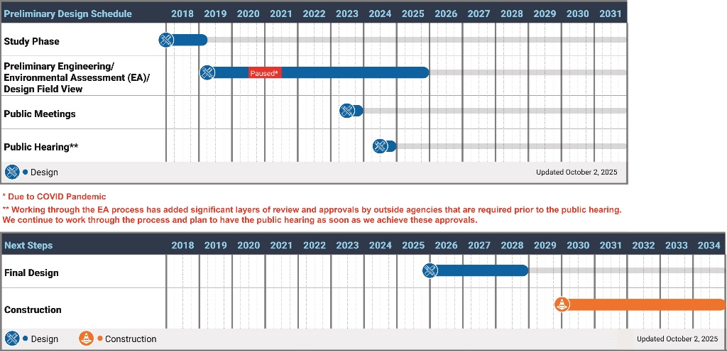
Based on the directive from the Federal Highway Administration (FHWA), the project team has continued to work through the Environmental Assessment (EA) process. Assembling the EA documentation is a more complex and lengthier process than what is required for a project designated as a CE. This process has added significant time, effort and layers of reviews and approvals from outside agencies. We are actively going through the EA process and are evaluating any way that we can streamline the schedule and help expedite review times from outside agencies to the best of our ability. As a result of needing these approvals prior to having a public hearing, we have had to alter our original schedule of a Fall 2022 public hearing. We are currently anticipating a public hearing in 2023.     


Please see the updated FAQs for additional information about the EA process. 


Winter 2021/2022

As we close out this year and begin planning for the next, we wanted to provide you a short update.

Earlier in December, the Pennsylvania Turnpike Commission (PTC) and other transportation officials participated in a press conference to announce that the engineering-design work on the Scranton Beltway Project has resumed now that the PTC has largely been released from a 2007 state mandate to provide $450 million annually to PennDOT to fund transit operations statewide. As was noted at the press conference, preliminary engineering design work is underway and scheduled to continue through the first half of 2022.

This announcement was in line with the project letter, dated August 16, 2021, which had been mailed to those within the general project area. The project website has been updated.

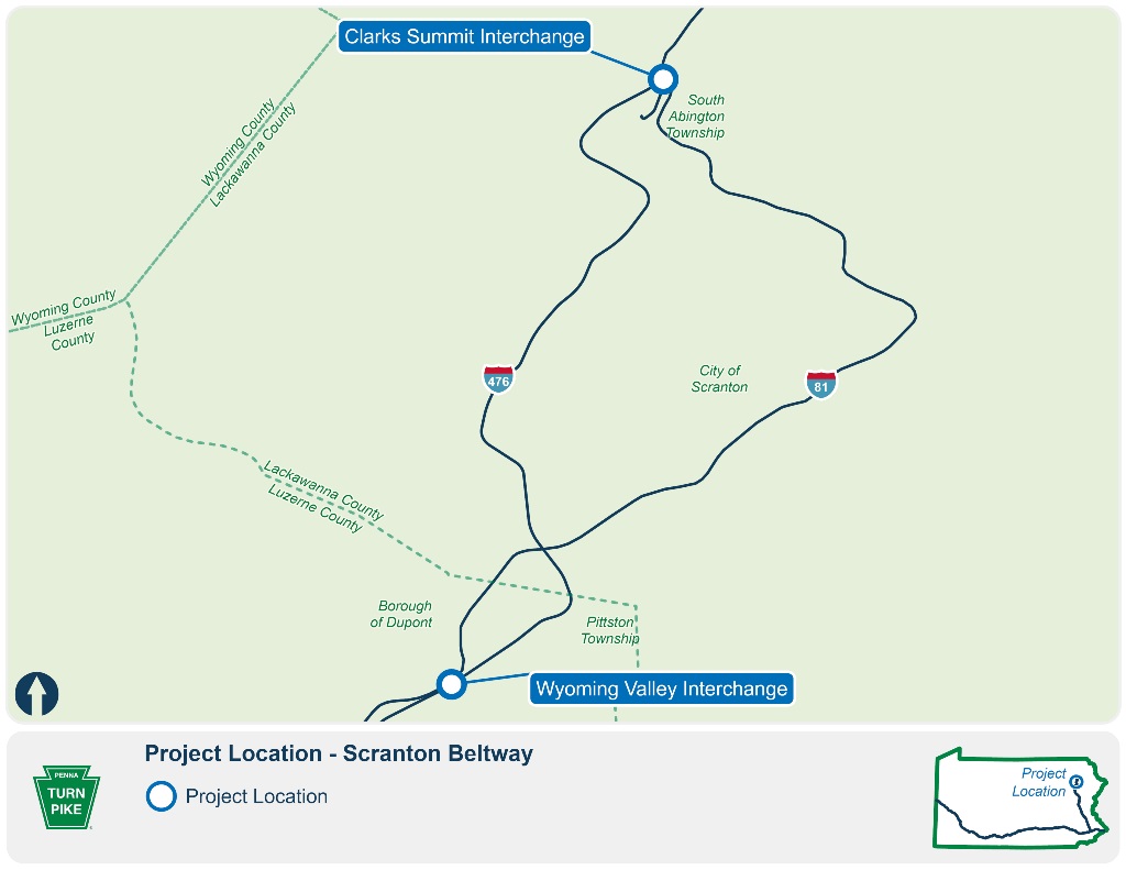
Locating the existing underground utilities in the Wyoming Valley Interchange and Clarks Summit Interchange study areas is anticipated to begin. These underground utility investigations will be performed by equipment, similar to those in the pictures below. If there is a disturbance to the area, it will be restored to original conditions after completion of the drilling.

This work, which was previously anticipated to occur during 2020, had been temporarily paused due to COVID-19 and funding. This work is now anticipated to commence in January 2022.

See the entire press conference here.

Winter 2020 News Photo

Winter 2020

Boring/drilling at the Wyoming Valley Interchange study area began shortly after Labor Day 2019, and is complete. Boring/drilling at the Clarks Summit Interchange study area began Mid-October 2019 and was recently completed.

The design team anticipates performing video inspections of existing storm drainage systems and existing culverts for storm drainage analysis.

Locating the existing underground utilities in the Wyoming Valley Interchange and Clarks Summit Interchange study areas is anticipated to begin. These underground utility investigations will be performed by equipment, similar to those in the pictures below. If there is a disturbance to the area, it will be restored to original conditions as much as possible after completion of the drilling.

The PTC and their Design Team are progressing with environmental studies and preliminary engineering design and are still on schedule to conduct a public meeting in the Fall of 2020.

Construction of the Turnpike's Edella Road bridge replacement project will start up again in the Spring of 2020. This project is not part of the Scranton Beltway project, but is part of the Commission's system wide program to address bridges in need of repair/replacement.

Winter 2020 News Photo

Design and Field Work

Fall 2019

Noise monitoring measurements have been completed at the Wyoming Valley Interchange study area. Noise measurements are anticipated to be completed at the Clarks Summit Interchange study area around the end of June. See the Sound Decisions About Highway Noise Abatement for more details on this process.

Boring/drilling at the Wyoming Valley Interchange study area began shortly after Labor Day 2019, and will continue into the fall. Boring/drilling at the Clarks Summit Interchange study area is anticipated to begin Mid-October 2019. These geotechnical drilling investigations will be performed by a drill rig, similar to those in the pictures below. If there is a disturbance to the area, it will be restored to original conditions as much as possible after completion of the drilling.

The design team anticipates performing video inspections of existing storm drainage systems and existing culverts for storm drainage analysis.

Locating the existing underground utilities in the Wyoming Valley Interchange and Clarks Summit Interchange study areas is anticipated to begin.

The PTC and their Design Team are progressing with preliminary design and are still on schedule to conduct a public meeting in the Fall of 2020.

Construction of the Turnpike's Edella Road bridge replacement project is underway. This project is not part of the Scranton Beltway project, but is part of the Commission's system wide program to address structurally deficient bridges.

Fall 2019 Drilling

Summer 2019

Noise monitoring measurements have been completed at the Wyoming Valley Interchange study area. Noise measurements are anticipated to be completed at the Clarks Summit Interchange study area around the end of June. See the Sound Decisions About Highway Noise Abatement for more details on this process.

The project geotechnical team is preparing a subsurface exploration program to determine the existing soil and rock conditions in the Clarks Summit Interchange study area and Wyoming Valley Interchange study area that may impact roadway design. They are identifying areas where more soil and rock, mines, and/or water related information is needed. The specific areas of this investigation include cut slopes, embankments, potential mine locations, and specific subgrade conditions. The specific areas of investigation are delineated based on the anticipated subsurface conditions.

Field survey crews will stake-out the proposed roadway boring locations within the project study areas and along the Turnpike and PennDOT roadways starting in late June.

Boring/drilling and lab testing is anticipated to begin after the Fourth of July 2019. These geotechnical investigations will be performed by a drill rig, similar to the pictures below. If there is a disturbance to the area, it will be restored to original conditions after completion of the testing.

The design team will perform video inspection of existing storm sewers and existing culverts for storm drainage analysis.

Fall 2019 Drilling

Spring 2019

Field survey crews continue survey work needed for base mapping and ground features in areas inside and outside the Turnpike and PennDOT right-of-way, and along the roadway shoulders at the Wyoming Valley Interchange and the Clarks Summit Interchange areas.

Sound Level Meter And Stand

Noise Analysis Team

The project noise analysis team identified noise study areas and noise receptor sites that are proposed for traffic noise monitoring in the Clarks Summit Interchange study area and in the Wyoming Valley Interchange study area. The proposed noise measurements are intended to define the existing noise environment at sensitive receptor sites, verify any possible new development in the project area, define background ambient noise levels, and determine the worst case noise hour. The number and location of the proposed noise measurement sites [approximately 10 to 15 minutes at most measurement sites] is influenced by topography, relative location in relation to each other, and local road traffic in the area. Noise measurements are anticipated to start in mid to late May 2019.

See the Sound Decisions About Highway Noise Abatement for more details

Environmental Team

The project environmental team continues to investigate cultural resources which include historic structures and archaeological resources. The environmental team is also continuing to study wetlands and streams, and protected plants and animals.

Fall-Winter 2018-2019

Field survey crews continue survey work needed for base mapping in areas inside and outside the Turnpike and PennDOT right-of-way, and along the roadway shoulders at the Wyoming Valley Interchange and the Clarks Summit Interchange areas. Survey tasks include locating existing survey information in the field, verifying accuracy of the project mapping, and stream surveys for environmental studies.

Coordinate video inspection of existing storm sewers and existing culverts for storm drainage analysis.

Determine noise monitoring activities and mapping to identify proposed noise measurement sites.

Initial Design Team Field Surveys & Data Collection

Summer 2018

The project team conducted field work along the project corridor in support of initial project tasks - a Point of Access Study and Preliminary Engineering. Site visits were made to gather data and observe traffic as part of the analysis of existing conditions. The project team coordinated with local municipalities to obtain data.

Field survey crews conducted initial survey work needed for base mapping in areas outside and inside of the Turnpike and PennDOT right-of-way, and along the roadway shoulders at the Wyoming Valley Interchange and the Clarks Summit Interchange areas. Survey tasks included locating existing survey information in the field, verifying accuracy of the project mapping, and stream surveys for environmental studies.

The project traffic team performed site visits to gather field data along the study area roadways and at the study intersections for use in the traffic analyses. The team took pictures of the study area and recorded field data. This data included documenting speed limits, timing/phasing of traffic signals, traffic control restrictions, lane widths and usage, signing (including major guide signs), and grades. They collected turning movements (both manually and with automatic traffic recorder (ATR) counts), and origin-destination data.

The project geotechnical team performed site inspection work along the project corridor to verify information obtained through document research, and to observe items for subsurface exploration and design. This field reconnaissance was done in both directions along I-476 between MP A-129.0 and MP A-130.5, and in both directions along I-81 between SR 4019 (Edella Road) to SR 4023 (Simerell Road) in the Clarks Summit Interchange study area. Site inspection work was also performed in both directions along I-476 between MP A-115.0 to MP A-116.5, and in both directions along I-81 between SR 2035 (Suscon Road) and SR 0315 (Navy Way Road) in the Wyoming Valley Interchange study area.

The project environmental team delineated wetlands adjacent to I-81 in both directions, and within the median from approximately SR 4019 (Edella Road) to SR 4023 (Simerell Road) near the Clarks Summit Interchange, and between SR 2035 (Suscon Road) and Navy Way Road near the Wyoming Valley Interchange. Wetlands were delineated adjacent to the Turnpike in both directions at the Wyoming Valley Interchange Area (MP A-115 to MP A-116.5) and Clarks Summit Interchange Area (MP A-131).

The project noise analysis team reviewed project information and layout in preparation for corridor noise studies.

More Project Resources

Project Overview

Learn about the Scranton Beltway project.

Learn More

News & Public Involvement

Learn how we stay connected with the public about this project.

Stay Updated

Team & Contact Information

Learn about the team that we will work with to complete the work on this project.

Contact the Team