Stay in the know. Sign up for The Road Ahead to receive the latest PA Turnpike news.

Chat With Us

PA Turnpike Skip to main content
Restore English
Restore English
  •  E-ZPass Login
  •  Pay a Bill
  •  Toll Calculator
  •  Open Road Tolling
  •  Help Center
  •  About Us FAQs
  • E-ZPass
    • About E-ZPass
    • Purchase an E-ZPass
    • Register my E-ZPass
    • Personal Account
    • Commercial Account
    • Toll Calculator
    • All-Electronic Tolling
  • Toll By Plate
    • About Toll By Plate
    • Pay a Bill
    • Toll Calculator
    • PA Toll Pay App
    • All-Electronic Tolling
    • Open Road Tolling
    • Unpaid Tolls/Enforcement
  • Traveling
    • About Traveling
    • Toll Calculator
    • Active Travel Advisories
    • Service Plazas
    • Safety
    • 511PA Travel Information
    • Construction Projects
  • Commercial
    • About Commercial Travel
    • Commercial E-ZPass
    • Permits & Restrictions
    • Service Plazas
    • Toll Calculator
    • Hazardous Materials
  • Business Hub
    • About Working with Us
    • Vendor Portal
    • Vendor Guide
    • Bids & RFPs
    • Vendor Resources
    • Investor Relations
    • Existing Innovation Submission

Allegheny Mountain Realignment - News

Allegheny Mountain Realignment  News
  • Overview
  • News
  • Improvements
  • Engagement
  • Contact

Design Update

Stay up to date on the latest updates from our design activities.
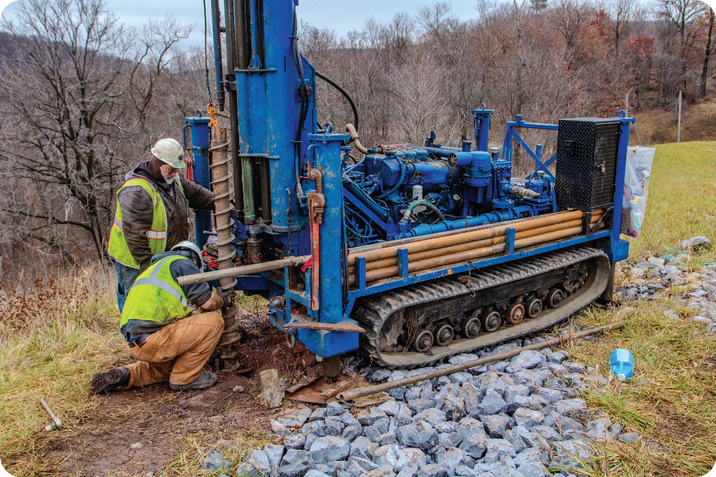
 

AMR Geotechnical Drilling


Summer 2026 Update

As part of ongoing environmental and engineering studies for the Allegheny Mountain Realignment Project, you may see field crews working in and around the study area over the coming months.

What Property Owners Should Expect

  • Field staff will carry identification and wear construction vests.
  • Minimal disturbance. Small soil collection will be completed as required.
  • Temporary equipment such as sound recording devises, cameras, and marking tape and flags may be placed at this time. 
  • No construction activities are taking place, only core drilling and field studies/surveys.   

Above Ground Historic Resource Survey

  • Purpose: To identify structures that are 45 years and older to evaluate their historic significance. Staff collected information on structure types and approximate date of construction. 
  • Summer Update: This field work was completed in April.  

Archaeology Field Studies

  • Purpose: A team of four will identify the presence of sites with archeological importance within the project area. 
  • Activities:
    • Walking survey, surface condition review, metal detection, hand excavation up to three feet, and soil screening
    • The team will use cameras, handheld GPS units, handheld soil probe tools, metal detectors, shovels, and screens
  • Summer Update: This work is 50 percent complete. Property owners should expect to see field crews walking the study area. Additional work will include hand-dug excavation of soils up to three feet in depth using wire mesh shaker screens, tarps, and spade shovels, as well as non-excavation investigation methods (metal detection). 

Wetland & Stream Investigations

  • Purpose: A team of up to four will locate and delineate the edges of wetlands and streams within the project area.
  • Activities:
    • Walking survey, wetland/stream boundary flagging, soil digging up to18 inches
    • The team will use cameras, shovels and a soil auger
    • Please note that flags may stay in place for a period of time as surveyors work behind the crews to survey the flag locations. The survey crew will remove the flags as their work progresses.
  • Summer Update: This work is 80 percent complete. Property owners should expect to continue to see field crews on site through July. 

Noise Monitoring

  • Purpose: A crew of up to four will monitor noise levels 
  • Activities:
    • Placement of temporary noise monitors near homes, businesses and other receptors. 
    • The team will use portable acoustic monitors, and equipment may remain onsite for more than 24 hours. 
  • Summer Update: This work is about to begin.  Property owners should expect to see field crews on or adjacent to their properties monitoring existing noise levels. Noise meters may be in place for more than 24 hours. 

Threatened & Endangered Species Studies

  • Purpose: To study various species including bats and the Allegheny Woodrat 
  • Activities:
    • Up to six people could be conducting this work depending on activity
    • Activities include Mist netting, photography, radio telemetry, and cave mapping. Some night work may be included as part of this study.
    • If night work is required, the project team will notify property owners ahead of time that there will be studies performed at night.
  • Summer Update: This work is 50 percent complete.  Property owners should expect to continue to see field crews on site through July. Additional information regarding these studies is available in this blog post.  

Community Facilities and Environmental Documentation

  • Purpose: To identify community facilities and services within the project area
  • Activities: A team of two will conduct windshield surveys and environmental data collection 
  • Summer Update: This work is planned for later this summer.  Property owners should expect to see field crews, viewing and cataloging public use properties such as schools, libraries, hospitals, clinics, and emergency services (fire, police, EMS). Places of worship, parks, government, and civic buildings. 

Geotechnical Drilling

  • Purpose: To bore holes into the ground to collect soil and rock samples 
  • Activities:
    • A team of up to three per track drill rig that will include geologists conducting soil and rock sampling
    • Equipment being used includes track drill rigs, a water truck, backhoe or dozer for access and clearing or grubbing, storage for core boxes, and personal vehicles for crew and field geologists
  • Summer Update: This work is 50 percent complete. Properties owners should expect to see this work continue through the summer and into the fall. 

Water Resources

  • Purpose: A water quality monitoring plan is being developed to address concerns raised by the public, elected officials and project stakeholders. The program will include pre-construction, construction, and post-construction monitoring. Coordination with property owners and stakeholders within the project vicinity is expected to begin this summer.
  • Activities: A team of up to two people will survey the area identifying, sampling and cataloging water sources.
  • Summer Update: The monitoring plan is under development, and field work is anticipated to occur late summer. 

Construction Management Services

  • During the July 7, 2026, Pennsylvania Turnpike Commission Meeting, the Commissioners selected TRC Engineers, Inc. to provide Construction Management services for the Allegheny Mountain Realignment Project, providing construction expertise throughout the design process to identify potential challenges and develop a safer, more feasible and constructable design.
  • Adding construction management services during the design phase, which has been done with other PA Turnpike projects, does not move construction closer or change the project's timeline.

Spring 2026 Update

As part of ongoing environmental and engineering studies for the Allegheny Mountain Realignment Project, you may see field crews working in and around the study area over the coming months.

Above Ground Historic Resource Survey

  • Purpose: To identify structures that are 50 years and older to evaluate historic significance. To collect information on structure types and approximate date of construction
  • Crew Size: 2 people
  • Activities: Roadside review, exterior photography, limited walking on properties
  • Equipment: Cameras, handheld GPS units

Archaeology Field Studies

  • Purpose: To identify the presence of sites with archeological importance within the project area.
  • Crew Size: Up to 4 people
  • Activities: Walking survey, surface condition review, metal detection, hand excavation up to ~3 feet, soil screening
  • Equipment: Cameras, handheld GPS units, handheld soil probe, metal detectors, shovels, screens

Wetland & Stream Investigations

  • Purpose: To locate and delineate the edges of wetlands and streams within the project area
  • Crew Size: Up to 4 people
  • Activities: Walking survey, wetland/stream boundary flagging; soil digging up to ~ 18 inches
  • Equipment: Cameras, shovels, soil auger
  • Please note that flags may stay in place for a period of time as surveyors work behind the crews to survey the flag locations. The survey crew will remove the flags as their work progresses.

Noise Monitoring

  • Purpose: To monitor noise levels
  • Crew Size: 2–4 people
    Activities: Placement of temporary noise monitors near homes, businesses and other receptors; equipment may remain for 24+ hours
  • Equipment: Portable Acoustic Monitors

Threatened and Endangered Species Studies

  • Purpose: To study various species including bats and the Allegheny Woodrat
  • Crew Size: Up to 6+ people depending on activity
  • Activities: Mist netting, cameras, radio telemetry, cave mapping (some night work)
  • In the case of night work, the project team will notify property owners ahead of time that there will be nighttime studies.

Community Facilities and Environmental Documentation

  • Purpose: To identify community facilities and services within the project area
  • Crew Size: 2 people
  • Activities: Windshield surveys and environmental data collection 

Geotechnical Drilling

  • Purpose: To bore holes into the ground to collect soil and rock samples 
  • Crew Size: 2 people per track drill rig; 2-3 field geologists 
  • Activities: Soil and rock sampling 
  • Equipment: 2-3 track drill rigs, a water truck, backhoe or dozer for access and clearing or grubbing, storage for core boxes, personal vehicles for crew and field geologists

What Property Owners Should Expect

  • Field staff will carry identification and will wear construction vests
  • Minimal disturbance — small soil collection only as required 
  • Temporary equipment placement may occur 
  • No construction activities — only core drilling, field studies/surveys 

Winter 2025-2026 Update

Geotechnical Investigations & Surveys

  • Conducted detailed underground investigations by drilling into the ground to collect soil and rock samples to analyze subsurface conditions.
  • Completed coordination and drilling inspection services for over 55 boreholes, with a combined depth of over 10,000 feet.
  • Marked 45 landslide monitoring monuments within the Ancient Slide area to delineate and quantify movement of the slope during the design.
  • Began affirming property lines and re-established the Turnpike roadway centerline at both ends of the project.
  • Located property evidence on the western half of the project.
  • Located right of way and alignment reference property monuments.
  • Continued survey of impacted streams for structure and relocation designs.

Environmental

  • Began more detailed studies on wetlands, wildlife, farmlands, and historic resources.
  • Continued coordination with the US Army Corps of Engineers, US Fish and Wildlife Service, the PA Game Commission, the PA Fish and Boat Commission and the PA Department of Conservation and Natural Resources through the PA Natural Diversity Inventory (PNDI) process in the assessment of Rare, Threatened and Endangered Species.
  • Began the development of a Noise Monitoring Plan.
  • Started the re-evaluation and update process for the project’s environmental document, which was previously completed in 2021.

Communications & Outreach

  • The Project Team continues to communicate with property owners adjacent to the Turnpike. These property owners received formal notification letters whenever there was fieldwork on their property.
  • Project update e-newsletters were sent in March and October to all those who have joined the mailing list. These included fieldwork updates and links to the website with information on frequently asked questions. 

Fall 2025 Update

Preliminary design is currently underway and includes detailed engineering and environmental fieldwork of the alternative currently under investigation. The goal of these studies is to collect data in an effort to minimize impacts to properties and the environment. Fieldwork began in March 2025. 

Property owners adjacent to the Turnpike received formal notification letters regarding upcoming fieldwork in the project corridor to the south of the existing tunnel. The initial work will begin in the PA Turnpike’s right of way. Field crews will then begin work required on private properties. Before entering private property, owners will be contacted and informed of the work plan.

The fieldwork includes: 

  • Surveyors are affirming property lines, marking core boring locations, marking geotechnical monitoring locations, and providing stakeout for the alignment under investigation.  
  • Geotechnical engineers are conducting rock and soil testing throughout the project area.
  • Environmental specialists have begun collecting additional field data and advancing the design investigations. These efforts include delineating wetlands and streams, performing archaeology work and collecting data to complete the biological assessment related to threatened and endangered species. 

Project updates will also be provided through this web page and by email. This will provide an opportunity for property owners and stakeholders to learn more about the design activities underway and what to expect moving forward.

To access Archived Study Phase Documentation, click here.


More Project Resources

Overview

Learn about this construction project.

Learn More

News

Learn the latest news about this project.

Stay Updated

Improvements

Learn about project improvements.

Learn More

Contact

Meet the team for this project.

Contact Team

  • About Us
    • Our Mission
    • Our Board of Commissioners
    • Commission Meeting Information
    • Our Executive Leadership
    • Design & Construction
    • PA Turnpike History
    • Investor Relations
    • Resource Library
    • Policies & Standards
    • Security & Fraud
    • About Us FAQs
  • News
    • Traffic Reports
    • The Road Ahead: Turnpike Newsletter
    • Stories from the Turnpike
    • Media Center
    • PA Turnpike Blogs
    • Right to Know Request
    • Law Enforcement Requests
    • Vehicle Registration Suspension Appeals
  • Responsibility Matters
    • Sustainability
    • Clean Water
    • Accountability
    • PA Mobility Partnership Reports
    • National Center for Missing and Exploited Children
    • Human Trafficking Awareness
  • Contract/PO Search
  • Careers
  • Contact Us
  • Site Map
  • Employee Login
  • Facebook
  • Twitter
  • Instagram
  • Linkedin
  • YouTube

©2026 The Pennsylvania Turnpike Commission